L’inventaire complet des espaces verts de la Ville de Paris — du grand parc au simple mur végétalisé ou à la jardinière de rue. 2 537 entités, pour 1 025 hectares au total (à comparer aux 25,4 ha supplémentaires livrés depuis 2020 — soit environ +2,5 % du patrimoine existant).
Code
ev |> dplyr::arrange(dplyr::desc(surface_totale_reelle)) |> dplyr::transmute(Nom = nom_ev, Type = type_ev, Arrondissement = ar, `Surface (ha)`=round(ha, 1)) |>head(8) |> gt::gt() |> gt::sub_missing(missing_text ="—") |> gt::tab_header(title ="8 plus grands espaces verts") |> gt::tab_options(table.width ="100%")
8 plus grands espaces verts
Nom
Type
Arrondissement
Surface (ha)
CIMETIERE PARISIEN DE PANTIN
Cimetières
0
107.6
CIMETIERE PARISIEN DE THIAIS
Cimetières
20
103.4
CIMETIERE PARISIEN DE BAGNEUX
Cimetières
20
61.5
CIMETIERE DE L'EST PARISIEN DIT DU PERE LACHAISE
Cimetières
20
43.2
PARC FLORAL DE PARIS
Promenades ouvertes
12
37.2
CIMETIERE PARISIEN D'IVRY
Cimetières
0
28.4
CIMETIERE PARISIEN DE SAINT-OUEN
Cimetières
0
27.1
PARC DES BUTTES CHAUMONT
Promenades ouvertes
19
24.7
Où sont-ils
Code
# Les vraies "destinations" vertes -- pas les jardinières, murs végétalisés# ou décorations de voirie, trop nombreux pour une carte de points lisible.espaces_notables <-c("Promenades ouvertes", "Cimetières", "Bois","Jardins privatifs", "Etablissements sportifs")pts_notables <- dplyr::filter(pts_sf, type_ev %in% espaces_notables)pal <- leaflet::colorFactor("Dark2", domain = espaces_notables)leaflet::leaflet(pts_notables, options = leaflet::leafletOptions(minZoom =11)) |>paris_basemap() |> leaflet::addPolygons(data = arr_sf, fill =FALSE, color ="#999", weight =1) |> leaflet::addCircleMarkers(radius =~pmax(3, pmin(16, sqrt(ha) *3)), stroke =FALSE,fillOpacity =0.75, fillColor =~pal(type_ev),label =~sprintf("%s — %.1f ha", nom_ev, ha),popup =~sprintf("<b>%s</b><br>%s<br>%.1f ha", nom_ev, type_ev, ha) ) |> leaflet::addLegend("bottomright", pal = pal, values =~type_ev, title ="Type", opacity =0.9)
Parcs, jardins, bois, cimetières et établissements sportifs seulement (653 sur 2537) — rayon des cercles ∝ √(surface).
Surface par arrondissement
Code
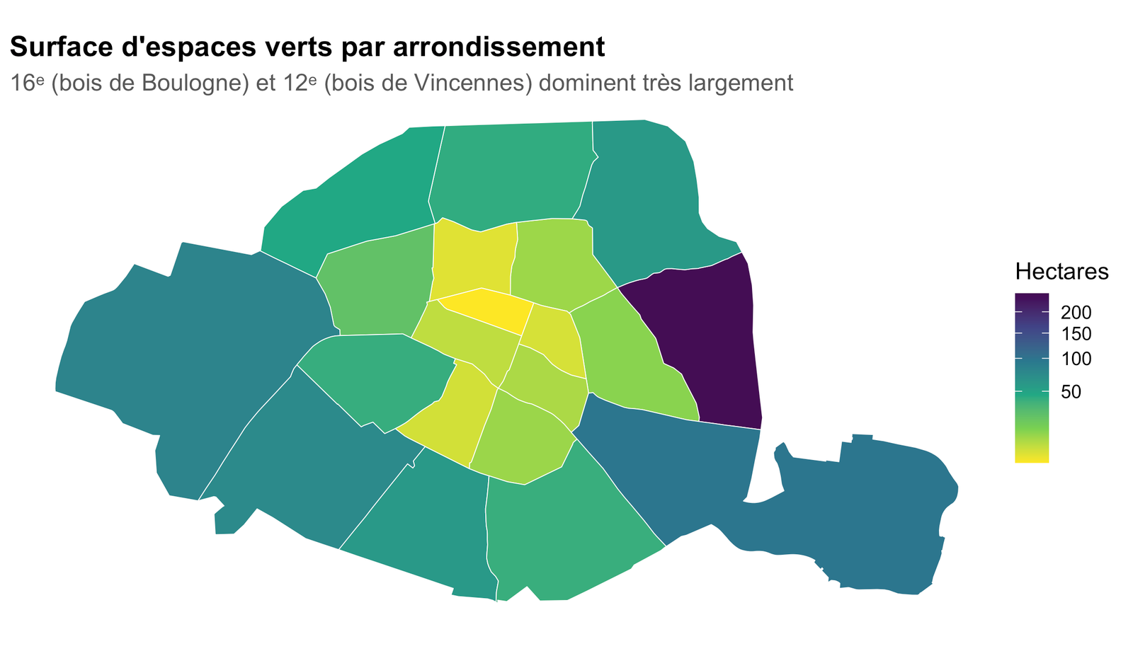
cnt <- ev |> dplyr::filter(!is.na(ar)) |> dplyr::group_by(ar) |> dplyr::summarise(ha =sum(ha, na.rm =TRUE), .groups ="drop")arr_sf |> dplyr::left_join(cnt, by =c("c_ar"="ar")) |>ggplot() +geom_sf(aes(fill = ha), colour ="white", linewidth =0.2) +scale_fill_viridis_c(option ="viridis", direction =-1, na.value ="grey92", name ="Hectares",trans ="sqrt") +labs(title ="Surface d'espaces verts par arrondissement",subtitle ="16ᵉ (bois de Boulogne) et 12ᵉ (bois de Vincennes) dominent très largement") + theme_carte
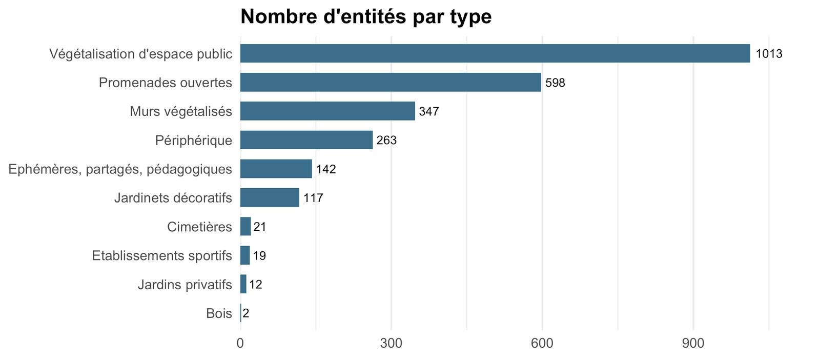
Beaucoup d’entités, peu de surface
Code
ev |> dplyr::count(type_ev, sort =TRUE) |> dplyr::filter(!is.na(type_ev)) |> dplyr::mutate(type_ev = forcats::fct_reorder(type_ev, n)) |>ggplot(aes(n, type_ev)) +geom_col(fill ="#3b6f8a", width =0.65) +geom_text(aes(label = n), hjust =-0.2, size =3) +scale_x_continuous(expand =expansion(mult =c(0, 0.12))) +labs(title ="Nombre d'entités par type", x =NULL, y =NULL) + theme_barres
Code
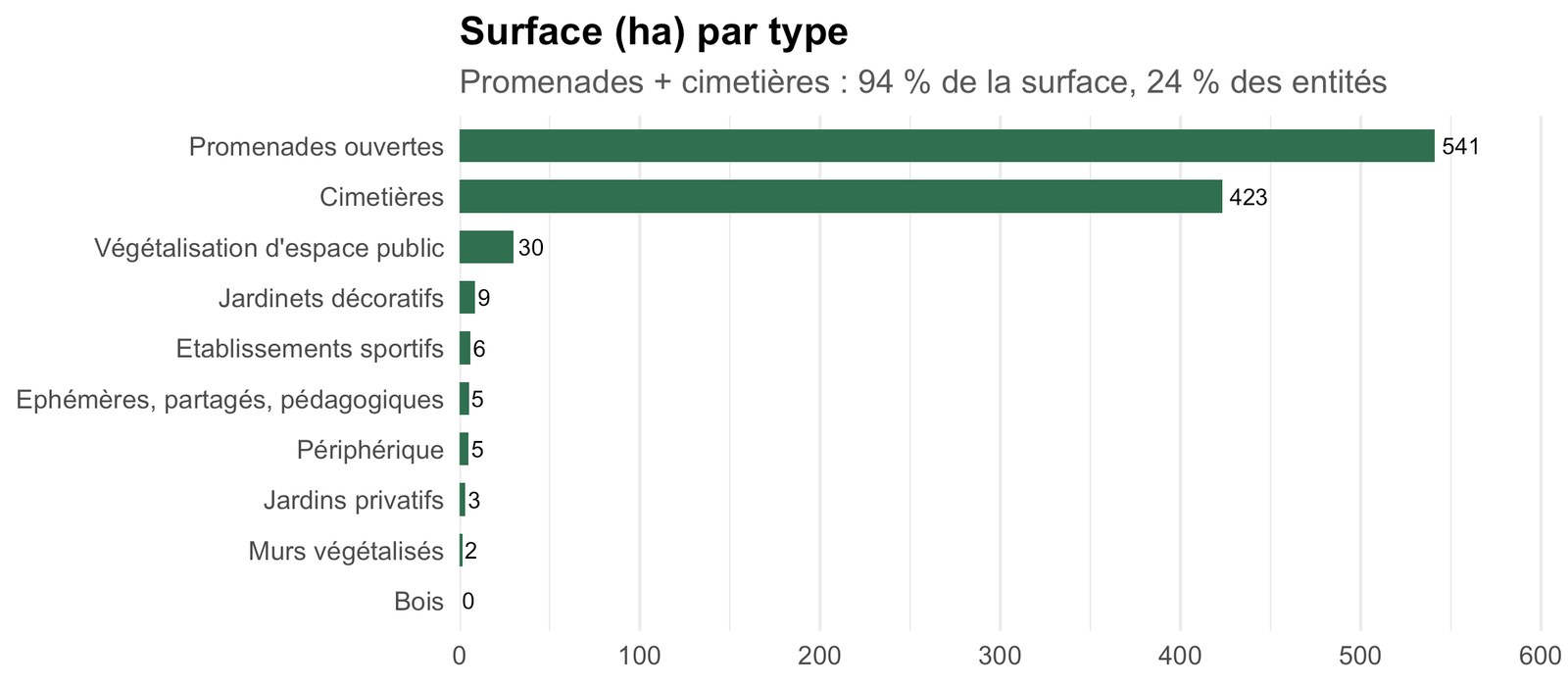
ev |> dplyr::filter(!is.na(type_ev)) |> dplyr::group_by(type_ev) |> dplyr::summarise(ha =sum(ha, na.rm =TRUE), .groups ="drop") |> dplyr::mutate(type_ev = forcats::fct_reorder(type_ev, ha)) |>ggplot(aes(ha, type_ev)) +geom_col(fill ="#2f6f4f", width =0.65) +geom_text(aes(label = scales::number(ha, 1)), hjust =-0.2, size =3) +scale_x_continuous(expand =expansion(mult =c(0, 0.12))) +labs(title ="Surface (ha) par type",subtitle ="Promenades + cimetières : 94 % de la surface, 24 % des entités",x =NULL, y =NULL) + theme_barres
« Bois » n’apparaît qu’à 0 ha : les deux bois parisiens (Boulogne, Vincennes, ~1 800 ha à eux deux) sont gérés par un système forestier séparé, sans surface calculée dans cette table — ce n’est pas une absence réelle.
Source & données
Code
tibble::tibble(``=c("Jeu de données", "Producteur", "Licence", "Fichier", "Mise à jour", "Observations"),``=c("[Espaces verts](https://opendata.paris.fr/explore/dataset/espaces_verts/information/)","Direction des Espaces Verts et de l'Environnement (DEVE) — Ville de Paris","Open Database License (ODbL)",sprintf("`data/paris/espaces_verts.parquet` (%s ko) + `arrondissements.parquet`",round(file.size(ev_path) /1024)),format(as.Date(file.mtime(ev_path)), "%d %B %Y"),sprintf("%s entités, %s ha", format(n_tot, big.mark =" "), scales::number(total_ha, 1)) )) |> gt::gt() |> gt::fmt_markdown(columns =``) |> gt::tab_options(table.width ="100%", column_labels.hidden =TRUE)